Friday, May 15, 2015

La Loire à vélo : Day 5 : Clisson to Nantes

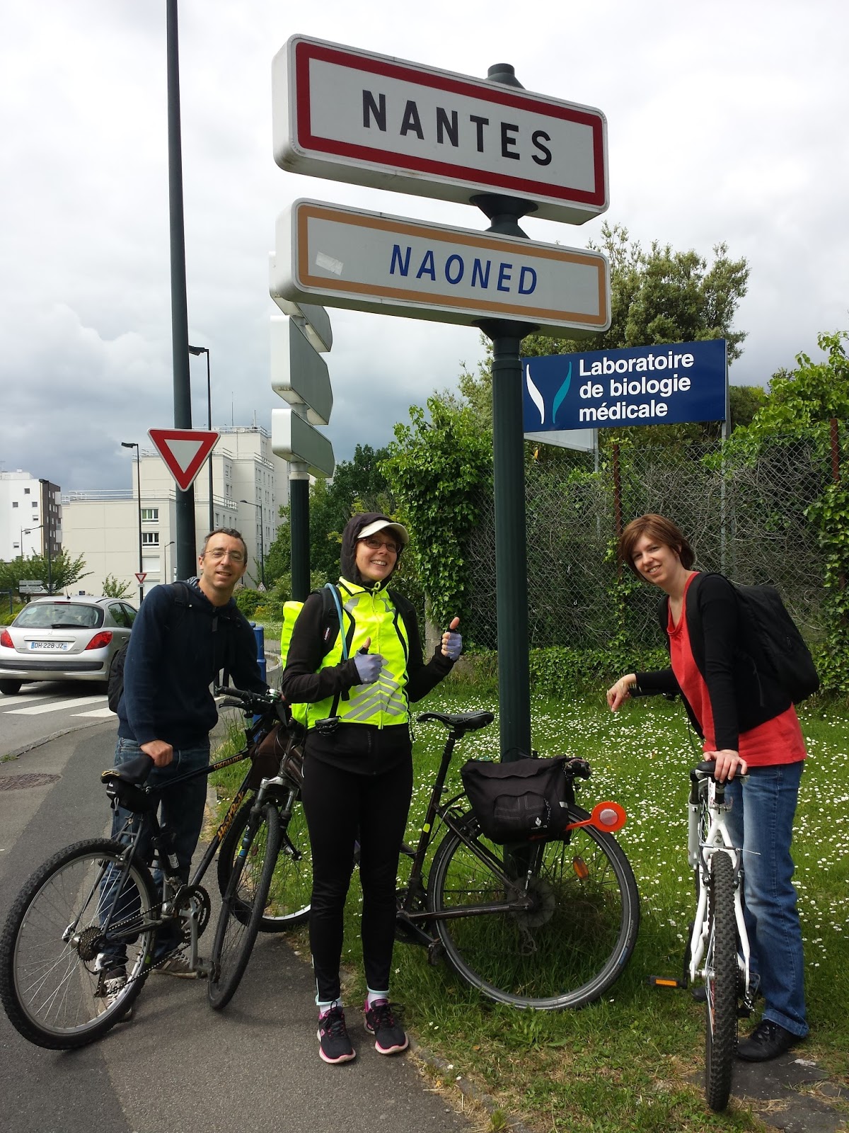
Today we recruited a couple of friends from Clisson to join us in the last leg of our bike tour, a 30km ride from Clisson to Nantes. It was nice to be cycling in a small group for a change.

We saw a flying saucer on the road, at La Haie-Fouassière. Technically, though, it was a parked saucer, not a flying saucer. The driver of this saucer looks like an Earthling astronaut though, and he is holding a cookie typical of the region. Several interpretations are possible, one of which is "this is your tax euros at work".

Nantes is in the Loire-Atlantique department, in the Pays de la Loire region, but there are references to Bretagne (the neighboring region) everywhere: souvenirs, restaurants, building and tramway stop names, signs in Breton... After the ten minutes I've just spent trying to inform myself on this matter, I can say that the separation (or possible future reunification rather) of Loire-Atlantique from Bretagne has been a subject of debate for decades. In 1956, Loire-Atlantique was separated administratively from Bretagne, even though historically they were associated for hundreds of years. In recent months, the French government has been "redesigning" the organization of the regions in France. Apparently the people in Bretagne and Loire-Atlantique were mostly in favor of reunification, but it looks like it won't happen after all. To understand why is left as an exercise for the reader. 

For dinner, we wandered about the streets of Nantes, hesitating between all the choices of restaurants. Finally we saw a sign that said "No bullshit, just burgers." If this restaurant is targeting American tourists  they are doing a good job, because that is where we ate. 

Below is a photo I forgot to include from the castle in Yseron: an extremely friendly and adorable dog greeted us and couldn't get enough of our affection.

Tomorrow we'll bid farewell to the Loire and say hello again to the Seine. 


Thursday, May 14, 2015

La Loire à vélo: Day 4: Yseron to Clisson

Today we only cycled 14 km from Yseron to Clisson. This is the path: https://connect.garmin.com/modern/activity/774541246

Before heading out on the road, we had a little chat with the owner of the castle we stayed at. He detected a "slight accent" and asked where we were from. I'm used to hearing this, but this time he said that Benoit also had an accent. I guess he's been hanging around me too long :-) The castle owner mentioned that he used to work in California, on the high speed train project. Maybe one day it will become a reality :-)

We expected heavy rains, but fortunately only had a few drops. We spent the day visiting with some friends: playing board games and geocaching.  We found 10 geocaches today, which is the most we've ever found in one day. Geocaching is definitely easier with a  four person team than with just two people.


Wednesday, May 13, 2015

La Loire à vélo : Day 3: Ancenis to Yseron

Today we probably cycled the least out of all the days on this tour so far, but it was the most tiring day. We said goodbye to the Loire river (for now) and headed south. We stopped to visit a zoo at La Boissière du Doré, where we spent the whole afternoon. Then we cycled over to Yseron, near Vallet, where we are spending the night in a castle. The roads were hilly, and there was a bit of traffic, but the weather was perfect. The path we took is here: https://connect.garmin.com/modern/activity/773588675

For dinner, we walked about 4 or 5 km to a pizzeria in Vallet, the closest city with restaurants. We found two geocaches on the route to the restaurant.

Tomorrow should be a nice and easy day: less than 15 km of riding planned,though the weather calls for rain!


Tuesday, May 12, 2015

La Loire à vélo : Day 2 : Saint Germain des Prés to Ancenis

Today we cycled from Saint Germain des Prés to Ancenis, stopping at Saint-Florent-le-Vieil. We had a delicious roasted chicken for lunch. I keep forgetting to take pictures of the food...

At Saint Florent, we tried to find a few Geocaches. If you don't know about Geocaching, it's a game in which people hide small boxes in miscellaneous public places, and publish the coordinates of the hidden boxes on a website. Geocachers try to find these boxes, and sign their names in tiny logbooks which are inside the boxes.

We only found one of the three we attempted. Yesterday, at Montjean, we also attempted to find a couple of Geocaches. We found both, but one of them was too high to reach to open to sign the logbook. We nevertheless marked it as "found" on the website, only to immediately receive a message from the owner of that cache saying we needed to mark it as "not found" since we didn't sign the logbook. Some people take this hobby way too seriously. On a previous trip to Amboise, we ran into a group of Geocachers who were in "speed"  mode, trying to find as many caches as possible, as quickly as possible, comparing their records (how many total caches found) with us.


There's not much else to say about today's trip: the weather was a bit cooler, but still pretty sunny. Tomorrow, we'll leave the Loire river and head south to Vallet. There is a zoo along the way: maybe we will visit it.


Monday, May 11, 2015

La Loire à vélo : Day 1: Angers to Saint Germain des Prés

Once again faced with an obligation to take some days off (vive la France), I decided to take a small tour of part of the Loire river. This time, I'm not alone! Benoit decided to join me.  The tour is from Angers to Nantes, mostly following the Loire river, but with a deviation to Clisson, where we will visit some friends.
Sunday morning we took our bikes and ourselves to Angers, by train. It wasn't a cycling day though: we spent the day visiting the city of Angers, mostly the castle. The weather was beautiful - even on the hot side.

Today, we cycled from Angers to Saint Germain des Prés, just over 30km. This is a popular route for cyclists, and there are signs indicating the cycle route, the whole way.

Part of the road was a bit rough, the road covered by small rocks. A mountain bike wouldn't have any problem. However, our bikes are hybrids (vtc in French) - with tire thickness between mountain bike and racing bike tire widths. We made it through those parts of the route without getting any flats, but I'm not sure a road bike would handle the terrain well.

My bike has, for each brake, a tiny screw near the brake barrel adjuster and the brake lever. As you screw it in, the brake lever closes. I guess the purpose is to have the brake levers closer to the handlebars to minimize the reach required by your fingers, to brake.  At some point, I'm guessing due to the vibrations on the rough road, this screw, on the rear brake side, managed to screw itself all the way in, thus leaving my brake lever practically completely closed and my rear brakes always on. The fix is of course simple : simply take the Allen key of the correct size and unscrew (or remove completely) this (useless) screw. Unfortunately, I didn't have the right size Allen key. I had two other keys, but not that one (thanks, Murphy). One of the two keys I had allowed me to find a workaround, though: I loosened the cable clamp bolt (near the brake pads), then loosened the cable which allowed me to separate the pads from the rim a tiny bit, and tightened the bolt again. It was good enough.

Just after this quick adjustment, we went to a park to have lunch. A couple of cyclists there had all the imaginable tools you might need, and they were kind enough to lend me the right Allen key so I could do the proper fix. They were on a Nantes - Angers - Nantes tour. I guess if you're ever going to need some help from fellow cyclists in France, the Loire route is one of the best places to be. We also met a Danish couple at the Angers hotel who were on tour. I don't know where they had been already, but they were heading to Paris.

This tour has gotten off to a good start: beautiful weather, nice roads (except for the little bumpy part), mostly flat route, no wind, almost no traffic at all, and beautiful scenery.


Saturday, June 7, 2014

Brittany Rain Tour 2014 - Recap


Last week, I cycled about 340 km in Brittany France, starting from Brest in the west, and ending in the border between Brittany and Lower Normandy, visiting the Mont Saint-Michel.  I anticipated and prepared for a week full of rain, hence the tour name "Brittany Rain Tour 2014", but throughout the week, I only received a few drops.  I guess the Celtic sun god Belenos was with me.

As with previous tours, it was enjoyable to be out in the countryside and forget my e-mails for a week!


Maps

This is the path I took, as recorded by my GPS:

Brittany Rain Tour 2014 - Entire trip

You can see an interactive map of the entire trip here.

These are the daily steps of the tour.  Click on each map to see the the track in an interactive map with stats:

Day 1: Brest - Landerneau
Day 2: Landerneau - Morlaix
Day 3: Morlaix - Lannion
Day 4: Lannion - Guingamp
Day 5: Guingamp - Saint-Brieuc
Day 6: Saint-Brieuc - Pléven
Day 7: Pléven - Saint-Malo
Day 8: Saint-Malo - Pontorson


Blog posts

If you missed the daily commentaries and photos, you can catch up by following these links:

Stats

None of my blogs would be complete without a table or charts.

The following table shows the distance traveled each day, the time I was outside each day, the average speed (includes breaks) and average moving speed (only includes when I was cycling or walking).


Day Tour step Distance (km) Time Average speed (km/h) Average moving speed (km/h)
Day 1 Brest – Landerneau 26.49 03:01:20 8.8 11.7
Day 2 Landerneau – Morlaix 44.10 05:50:36 7.5 12
Day 3 Morlaix – Lannion 42.34 04:39:46 9.1 13
Day 4 Lannion – Guingamp 44.82 04:48:58 9.3 14.4
Day 5 Guingamp – Saint-Brieuc 45.69 04:53:38 9.3 14.3
Day 6 Saint-Brieuc – Pléven 39.12 03:13:31 12.1 16.3
Day 7 Pléven – Saint-Malo 49.84 04:25:17 11.3 14.8
Day 8 Saint-Malo – Pontorson 50.06 05:56:20 8.4 14.6
Total
342.46


Average
42.81 04:36:11 9.3 13.9


Since I traveled more lightly on this tour than previous tours,  perhaps because I had a real bike pump to inflate my tires to maximum recommended pressure, and probably because I paced myself better this time, compared to other tours, my average moving speed was about 14 km/h.

My previous tours, in comparison:
After I accumulate a few more tours, I'll include a graph of this data.

As for this trip, I took it easy this time, only cycling about 45 km per day, compared to 60 or 65 on previous trips.

Fun stats

  • This tour was:
    • about the distance walked by backpackers to create this HD time-lapse video of Yosemite National Park.
    • a bit longer than the distance of the "Total 200", a route covered by crazy cyclists in one day (miles version), which will take place next weekend.
    • just longer than the distance of the "Tahoe 200", a running race around lake Tahoe this fall which must be completed in 100 hours (just over 4 days).
    • about the distance from Long Beach to San Diego and back.
    • the distance Indian man Mani Manithan walked backwards, naked, to promote peace.
    • the distance blind Australian Liam Haven walked from Sydney to Canberra, for which he was awarded the Guide Dogs Victoria's Freedom Award.
  • The tour was about 24 hours and 43 minutes of cycling time.  Depending on the source, this corresponds to between 5100 - 8000 calories burned during cycling.  This equals:
    • 10 to 15.7 French Big Macs (or 9.2 to 14.5 American Big Macs).
    • 108 to 170 McNuggets
    • 453 to 711 Life Saver candies
    • almost my body weight in celery

Cows

When I was on the road, I couldn't include videos in this blog.  Now that I'm at home, with a real computer, I can finally edit this blog normally.  Here's a video of some cows eating (very exciting!):


And the sun and clouds each day of the trip:

Conclusion

That's it!  Thanks to the people who followed along and commented.  Where will the next tour be.....?

Sunday, June 1, 2014

Brittany Rain Tour 2014 - Day 9

This morning, during breakfast at the hotel, I took a picture of my orange juice. Why? Well, I've noticed that in all the hotels where I've had breakfast, it's always a self serve buffet, and the plates and glasses are abnormally small, in some cases ridiculously small. I'm sure it's a psychological trick to make you take less food. It doesn't work on me though. If I know I'm going to be cycling for 4 or 6 hours, I eat accordingly. :-) But today,the glass for the orange juice was almost as small as a shot glass,so I had to take a picture. I think I got up to refill it five times. 

Today I visited the Mont Saint Michel. I was able to bike up to a parking lot which is about a 40 minute walk to the island, and leave my bags in a locker while I visited the site.

My first impression was that there wasn't much there besides restaurants and cheap souvenir shops. I had lunch in one of the restaurants there: I ordered moules frites. Afterwards, I bought a galette Bretonne from one of the shops: a huge cookie. I also bought a pin of the Breton flag, which I've put on my backpack to remind me of this trip.

On the road today, I saw:

* sheep

* horses

* tour bikes parked with all their gear left on the bike (I think we're still not in Paris anymore, Toto) 

* A family cycling on the same path as I. 

* A group of bike tourists at the train station

* cow sculptures which were not scary at all

* road signs warning about cyclists

* absolutely no grocery store open when I had two hours to wait for the train and wanted to buy a snack to munch on. 

So, while today has been a sad end to my trip, the rest of the trip was a perfect cycling trip: beautiful scenery, great cycling weather, conversations with cows, a visit with co-workers, not too difficult routes and distances. On my paper map (which is now "done"), I see there are some long distance cycling routes running North /South. Maybe I'll come back to Brittany for another "Rain Tour" some day!